The United States has its share of dangerous roads – mountainside passages in Colorado, isolated trucking routes in Alaska, speedy expressways cutting through tourist-heavy destinations.
But if you look beyond our country’s borders, you’ll find that these pale in comparison to the most harrowing roads in the world. These treacherous trails are a driver’s worst nightmare: sharp, winding routes through nearly impassable terrain, wide open to the wicked whims of mother nature, not to mention gravity. And not a guardrail in sight.
From the shores of the Norwegian Sea to the peaks of the Himalayan mountains, here are some of the world’s most nerve-racking roads.
Karakoram Highway
Pakistan and China
The Karakoram Highway is widely regarded as one of the most impressive engineering feats in recent times. The 800-mile road linking China and Pakistan is said to be the highest paved road in the world, reaching heights of more than 15,000 feet above sea level. That’s more than halfway to the top of Mount Everest. Because of this challenging terrain, construction of the Karakoram Highway took roughly two decades. It also claimed the lives of more than 1,000 workers, most of whom died in one of the region’s notorious, and frequent, landslides.
The mountainous home of the Karakoram Highway is the site of countless land- and mud-slides, rock falls, floods, avalanches and earthquakes. Add in hairpin turns and steep drops along the side and you have what many people consider the most dangerous road in the world.
Although open to the public, and a popular tourist destination, the Karakoram Highway is not for the faint of heart.
North Yungas Road
Bolivia
There is one place in Bolivia where vehicles travel on the left side: North Yungas Road. The exception is made here because it gives drivers a better view of the edge of the road – and the 2,000-foot drop beyond it.
Nicknamed “Death Road,” North Yungas features a a perfect storm of perilous driving conditions. The 43-mile path connecting Bolivia’s capital La Paz to the Amazonian town of Coroico is carved into the side of the Cordillera Oriental mountains. It descends nearly 12,000 feet, making it one of the longest stretches of continuous downhill road in the world.
The road itself is rarely more than 10 feet wide and plagued by landslides, fog and heavy rain. As a result, nearly 300 drivers died on the road annually, according to La Paz Life. At one point, cars were falling over the edge at a rate of once every two weeks.
In 2009, the Bolivian government built a new, safer route nearby. North Yungas Road, however, is still open to cars.
Atlantic Road
Norway
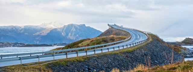
Norway’s Atlantic Road looks less like a traversable highway and more like a roller coaster-esque racecourse straight out of a video game. The 5.2-mile road snakes and undulates across the harsh Norwegian Sea, leaving itself susceptible to the blustery winds and crashing waves that accompany the area’s frequent storms. The dangerous road’s location delivers some otherworldly views, which explains the several designated viewing spots along the route. Just make sure to do your sightseeing on fair-weather days.
Guoliang Tunnel
China
Perusing the list of the world’s most dangerous roads, you’ll notice many are found alongside mountains. The Guoliang Tunnel, however, is carved into mountains, China’s Taihang Mountains, to be exact. Just 15-feet high, 13-feet wide and holding the distinction as one of the steepest roads in the world, the perilous tunnel was built out of necessity, according to the Daily Mail. Prior to 1972, the only access to the remote village of Guoliang was through a footpath consisting of 720 steps.
The village wanted to create a more accessible route to the outside world. Shockingly, it took just 13 local villagers to construct the nearly mile-long tunnel (along with 4,000 hammers, 12 tons of steel and five years’ time).
Driving on the road requires laser-like focus, as the path twists and turns without much notice. As if these hazards weren’t enough, motorists will also have to navigate around the crowds of footbound tourists looking to get a firsthand look at what has become a popular tourist attraction.
Passage du Gois
France
The Passage du Gois is a nearly three-mile road located along France’s Atlantic coast, connecting the mainland to the island of Noirmoutier. At first glance, it may seem like a safe, serene roadway. But, twice a day, like clockwork, the Passage du Gois becomes one of the world’s most dangerous roads. Because the path is essentially at sea level, when the tide comes in, it’s flooded under several feet of water.
Digital panels inform drivers when the road is passable. As you can imagine, not everyone obeys these warnings, leading to many a trapped tourist. Elevated towers have been placed along the road for stranded travelers to wait out the tide.
https://www.youtube.com/watch?v=W-qSN1SmeLo
Zoji Pass
India
Any list of the world’s most dangerous roads surely must include one that winds through the most treacherous terrain on Earth: the Himalayan mountains. Situated more than 11,500 feet above sea level, the 16-mile pass connects Ladakh and Kashmir. The winding, partially unpaved road is most perilous due to the region’s notoriously brutal weather. Zoji La Pass is typically closed during the winter due to snowfall that can total more than 50 feet. There have also been at least 60 landslides fall across the roadway, according to the Daily Mail.
Bayburt-Of Road
Turkey
Zigzagging up the 6,000-foot-high Soganli Mountain, with no guardrails to speak of, is the northern section of Turkey’s state road D915, known as Bayburt-Of Road. The passageway was built back in 1916, but we use the term “built” generously, as the road is made of nothing more than dirt and loose gravel.
All told, the dizzying drive contains 29 hairpin turns. Add in a crumbling road conditions, sections so narrow they can barely fit two cars, and unpredictable snow, blizzards and fog, and you have a road to be avoided at all costs.
Sichuan-Tibet Highway
China
When you think of what makes these roads so dangerous, you’d likely form a list of the usual suspects: sharp turns, poor infrastructure, crowded paths, hazardous weather conditions, etc. One factor that probably wouldn’t come to mind, though, is altitude sickness.
The Sichuan-Tibet Highway spans more than 1,300 miles across China. Along the way, it traverses more than a dozen mountains that reach heights of over 16,000 feet. The air at that altitude contains half the amount of oxygen than at sea level. This can lead to symptoms such as dizziness, headaches and nausea.
But then you have to deal with the road itself, which consists of poor driving surfaces, hairpin turns around mountains and nerve-wracking bridge crossings. Did we mention the frequent snow, ice and landfalls?
Skipper’s Canyon
New Zealand
Just how dangerous is New Zealand’s Skippers Canyon Road? So dangerous rental car companies forbid customers from driving on it. Indeed, the route through the Skippers Canyon Gorge is not for the faint of heart – or the claustrophobic. The vast majority of the twisting, unpaved road is too narrow for more than a single car to pass. Should you encounter another vehicle on your journey, one of you will have to back up until you find a spot wide enough for you both.
Skippers Canyon Road was built by miners in the late 1800s during their search for gold. Unless you, too, want to test your luck, we suggest traveling the road via professional tour companies familiar with the route.
Have you driven on any of the most dangerous roads in the world? How was the experience? Let us know in the comments below!
Make sure to brush up on your safe driving tips before you go on your next four-wheel adventure.
9 Thoughts on “Are These The Most Nerve-Racking Roads in the World?”
Leave A Comment
Comments are subject to moderation and may or may not be published at the editor’s discretion. Only comments that are relevant to the article and add value to the Your AAA community will be considered. Comments may be edited for clarity and length.


I would include at least two Italian roads here: One is the one lane clifftop road to Faro di Capo Zafferano, shown here as a pathway. https://laterradiguttuso.it/escursioni-visite-guidate/escursioni-visite-guidate/passeggiata-in-bici-al-faro/passeggiata-al-faro-di-capo-zafferano/1407502,435273 It also is used by cars! Also, Via Pasitea in Positano on the Amalfi Coast. Watch out for oncoming tour buses on the winding cliffside road.
The road at the Northwestern point on Maui from Napili to Wialuku. It is not shown on maps as it truly exists. Suddenly, it turns to a single lane, washed out in places, up against the mountain on one side, unpaved road with no guard rails and steep drops. Once you are on it, you are committed and may have to be committed at the end. Makes the back part of the Hana Road look like a 2-lane highway.
Very cool videos, but the one with the lake was more about the lake than the road. Also acouple of them weren’t extremely dangerous- just interesting and maybe a bit scary. (Karakoam Rd and Atlantic hhighway.) Too bad there was no translation for the Zoji Pass one.
Khardungla Pass – Famously known as the gateway to the Nubra and Shyok Valleys in the Ladakh region of Jammu and Kashmir. It is the highest motorable pass in the world. It is filled with tourists crossing over from Leh and stopping long enough to click some photographs. Adventure bikers from all parts of our country and across the world visit this mountain pass on their motorcycles for an adventure soaked experience. Khardung La Pass is positioned on the Ladakh range, which is 40 km from Leh, at an altitude of 18,379 ft (5602 m).
It is incredible – views of the Nubra valley are from another planet. We crossed this pass on the way to Pangong Lake.
I think the Cross Bronx Expressway in NYC should be on that list !
No lie.
The road from Aqua Caliente in Peru to Machu Picchu used by the tour buses is quite harrowing. Both going up and down, there are buses at the bottom of the side of the road that have fallen over the edge and just left there. Lots of hairpin turns.
I have been on the Karakoram Highway from Skardu to Islamabad. An incredible experience! Just outside of Skardu there was a rockslide that shut down the road for about six hours until excavation equipment cleared the debris.
Skippers Canyon- 1982
Terence F. Gaffney Jr. © 2022- All Right Reserved
A sign at the entry into Skippers Canyon reads, ‘Narrow winding road with steep drop-offs, no safety barrier.’ Seven or eight warning signs for those who can’t read have pictures of rocks tumbling on cars, cars tipping on two wheels, squiggly zig-zag lines showing cars sliding, all of which make it obvious why rental car companies prohibit taking their vehicles here.
They might just as well have posted a sign reading, ‘abandon all hope, ye who enter here,’
Calling this a ‘road’ is an expansively abusive use of the word. It’s not much more than a track hewn from the sheer rock face hovering precipitously over a steep-walled gorge. The track dips and climbs anywhere from 200 to 1,000 feet above the Shotover River below. The stone is a soft, crumbly limestone, particles of which are easily crushed when squeezed between my thumb and forefinger. I’m glad conditions are dry, yet I wonder if every rut we encounter has the possibility of caving under the weight of the car.
Speed limit? 15km/h (9mph) … I don’t challenge it.
Guardrails? Hah. No room for them. I’ve seen wider driveways. The track averages nine feet in width, expanding in some stretches to twelve feet. There are only a handful of turnouts wide enough to accommodate two cars to pass one another, and none for the first three miles. Thankfully, we do not encounter a single car on our way in, since any such encounter would make for a sweaty-palm experience for whichever driver is forced to drive in reverse.
We pass through Hell’s Gate and Heaven’s Gate, two narrow splices cut through the rock before we come across the Shotover River Bridge.
The drive becomes far too interesting at a point where the track’s width shrinks to seven feet. There is zero room for error. It’s such a tight squeeze, I pull in the side view mirror so I can get the car four inches closer to the sheer rock face, and four inches farther away from the 600 foot drop-off down to the river.
Nancy and Kenny choose to get out of the car and walk ahead ‘just in case.’ I’d join them too, if I could.
On our way back, we are confronted by a tourist minivan on its way into the canyon. Kenny goes bonkers when I have to put the car in reverse and back up a quarter-mile to get back to one of the turnouts. He opts to get out and walk back, and convinces Nancy to do likewise… can’t say as I blame them.
We make it out of Skippers Canyon with no dents in the car, no scars on our bodies, but carrying a passel full of wonderful memories.