
AAA produced its first road map in 1905, a humble hand-drawn route on linen, depicting roads in Staten Island, N.Y.
Little did the cartographer know that this project would soon become a full-time position.
AAA expanded its horizons a year later, becoming the official sponsor of “The Official Automobile Blue Book.”
The book was the first collection of generalized road maps spanning Boston, New York, Baltimore, Washington and Philadelphia and was created by AAA Secretary Charles Howard Gillette.
AAA then established a Bureau of Touring Information in 1906, to supply members with all available data on roads, hotels, service facilities and motor vehicle laws.
The problem was, there wasn’t much information available. Most early maps were prepared for bicyclists and even the “Blue Book” was a generalized map, meaning it didn’t contain complete maps of every road.
So, AAA finished the job and soon began producing its own auto-oriented maps and road logs and, eventually, a series of Tour Book guides and camping directories.
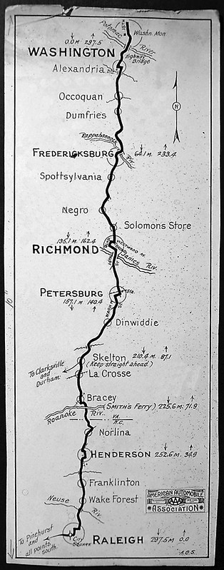
But it wasn’t until 1911 that the Club produced its first interstate map (right), “Trail to Sunset,” a booklet of strip maps detailing a route from New York to Jacksonville, Fla.
Today, a more sophisticated form of strip maps are combined to make what is known as Triple A® TripTik routings.

Related Articles


Trending Articles


NEWEST ARTICLES


5 Thoughts on “The Nation’s First Road Maps, Courtesy of AAA”
Leave A Comment
Comments are subject to moderation and may or may not be published at the editor’s discretion. Only comments that are relevant to the article and add value to the Your AAA community will be considered. Comments may be edited for clarity and length.

I have been a vintage map buyer and seller for 40 years. My living room walls are decorated with a variety of cool and valuable old maps, including a couple of early AAA maps. I just bought another AAA map of the USA from the 1920(s) that I want to display. Unfortunately, a lot of the early AAA maps are undated. It would be nice to know about the history of these old maps.
Is there a list of all the maps that are published by the AAA clubs in the U.S.
Hi Arthur,
Thanks for reading Your AAA Network, and great question! Let me look into it and I’ll get back to you as soon as I know. Stay tuned
Hi
Excuse me, but the sample map that shows the cities —from Washington to Richmond to Raleigh — seem DC, MD, VA & NC based locations — not Staten Island, NY, which the article mentioned. Does the 1905 map still exist, or is the pictured map the 1905? TY
That’s a great question Esther! I’ve been trying to track down a pic of that original Staten Island map myself, but the one featured in the article was part of the “Trail to Sunset” effort I believe.